The flat spell in NSW is about to come to an end as a big low-pressure system sweeps across the state this weekend. It is set to have more of an impact than you think.
It’s been six weeks since much of the east coast has had any waves rolling onto its beaches. The light westerly winds combined with the warm midday winter sun have created brisk yet, picturesque weekends on the golden sands.
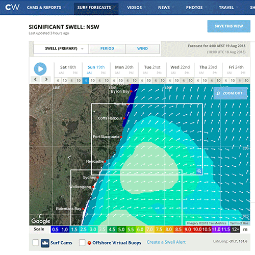
This Sunday we’ll see a return to typical winter weather patterns with solid surf and strong winds. Why is it significant for us? During prolonged flat spells, people forget about the ferocity of the ocean and this swell, although not super-sized, it will be a risk to those caught unaware by the change. Board, ski or ocean swimmers as well as rock fishermen are cautioned to check conditions before heading out.
Newport SLSC’s High-Performance coach Nick Carroll follows the swells closely and has laid out the facts about this system and what to expect at your beach.
“What’s going to happen, is there’ll be a cold air mass moving across the continent on Saturday. We’ll feel the effects on Sunday as the air temperature drops. On Monday morning, that cold air will travel out over the ocean and form an intense depression and bring with it a strong south-westerly wind, which could also mean the chance of a shower or two on Sunday night.”
As the swell strengthens, it will also change direction on Tuesday and Wednesday. It looks as if at this stage, the winds will drop and the weather with clear. But Nick says this is when issues can arise. “The weather will be nice but there will still be a solid groundswell which is dangerous especially for rock fishermen.”
As the larger surf moves in, you can expect to see the sand changing too. Nick says that during flat periods, sandbanks in the water and on the beach typically rebuild and repair themselves. “It means that a lot of beaches won’t have a big wave surf buffer at the moment and that with the increase in the size of the waves, you’re more likely to see the big waves breaking close to shore until the sandbar is eroded and moved further out to sea again.”
The consistent weather pattern over the last month that has also been responsible for pushing the last 5% of the state into drought could potentially come to an end with this disruptive system, says Nick. “There’s an outside, and it’s hard to predict at the moment, but there could be a bit of relief next weekend for inland NSW with what looks like a small amount of moisture moving in.”
So if you’ve got training planned for next week check conditions online before you go and make sure you watch what the swell is doing before heading out.
For more information stay tuned to Coastalwatch.com
Leading photo by Mandy Zieren
Friday 17 August 2018